
January 1973 · Volume/issue not printed or unknown
January 1973 Magazine

Magazine · 20 pages
Search this issue
For the full-resolution original, use Open PDF above. Your browser handles PDF zoom and navigation.
Searchable text for scan page 6
Canoeing The Vermilion River
by Sid Rommel
a
is ~ Sid Rommel has not only been active in
SS XK the MCA for a long time but also, and
CC probably for a longer time, been e and
The &s S around the Minnesota rivers. We plan to
_ Gorge - run this kind of article regularly and at the
“as ~ ey h be publish a collection
KD NS SSG Lake end of the year maybe pu ction.
203 S NSS
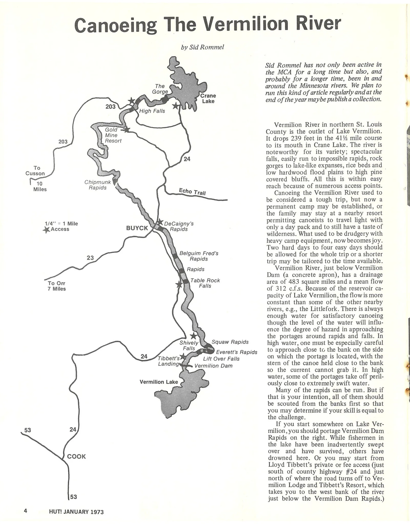
SSS Vermilion River in northern St. Louis
NS aa County is the outlet of Lake Vermilion.
203 N ie . It drops 239 feet in the 41% mile course
S to its mouth in Crane Lake. The river is
SSNS noteworthy for its variety; spectacular
Qs 24 falls, easily run to impossible rapids, rock
To N gorges to lake-like expanses, rice beds and
S > = . A <
Cusson SSS low hardwood flood plains to high pine
70 Chipmunk @ covered bluffs. All this is within easy
Miles Rapids = E reach because of numerous access points.
SX cho Trail Canoeing the Vermilion River used to
Ss be considered a tough trip, but now a
\ permanent camp may be established, or
W P
NS the family may stay at a nearby resort
SN rmitting canoeists to travel light with
1/4" = 1 Mile NS DeCaigny’s pe
53
4
SS :
Access BUYCK Dae Rapids only a day pack and to still have a taste of
* \ . wilderness. What used to be drudgery with
heavy camp equipment, now becomes joy.
Two hard days to four easy days should
SS
23 ‘ee ai be allowed for the whole trip or a shorter
“ee trip may be tailored to the time available.
\S Rapids Vermilion River, just below Vermilion
\ Dam (a concrete apron), has a drainage
To Orr e aie Fase area of 483 square miles and a mean flow
7 Miles aN = of 312 c.f.s. Because of the reservoir ca-
KS pacity of Lake Vermilion, the flow is more
&Xy constant than some of the other nearby
SA rivers, e.g., the Littlefork. There is always
aN enough water for satisfactory canoeing
N though the level of the water will influ-
SN ence the degree of hazard in approaching
S the portages around rapids and falls. In
Shively SN. Squaw Rapids high water, one must be especially careful
als a= 1 to approach close to the bank on the side
24 A ribbett’s > Lift oe on which the portage is located, with the
Landing S Vermilion Dam stern of the canoe held close to the bank
NS S so the current cannot grab it. In high
7 S <« water, some of the portages take off peril-
Vermilion Lake 2. S ously close to extremely swift water.
7 .. Many of the rapids can be run. But if
a that is your intention, all of them should
»_ be scouted from the banks first so that
you may determine if your skill is equal to
S the challenge.
If you start somewhere on Lake Ver-
24 milion, you should portage Vermilion Dam
Rapids on the right. While fishermen in
the lake have been inadvertently swept
over and have survived, others have
COOK drowned here. Or you may start from
Lloyd Tibbett’s private or fee access (just
south of county highway #24 and just
north of where the road turns off to Ver-
milion Lodge and Tibbett’s Resort, which
takes you to the west bank of the river
53 just below the Vermilion Dam Rapids.)
HUT! JANUARY 1973
Article contents & approved summaries (0)
No article summaries are available for this view.