
March 1973 · Volume/issue not printed or unknown
March 1973 Magazine
Magazine · 20 pages
Search this issue
For the full-resolution original, use Open PDF above. Your browser handles PDF zoom and navigation.
Searchable text for scan page 7
Turtle and White Rapids are boulder
bed again, and are relatively short; but the
volume is larger than the above sections.
Willows, tall grass, and sand banks give
one the impression that the Wolf is nearly
spent and off the Canadian Shield. Big
Eddy Falls destroys this illusion. Big
Eddy consists of two big drops about 100
yards apart. Hydraulics at the base of each
drop are nasty. The view from the middle
of the river looking back at Big Eddy is
unforgettable.
The Wolf is quickly becoming the most
popular rafting stream in the country.
Rafts tend to hang up and bund up in
narrow areas so caution must be exercised
when approaching constricted areas with
poor visibility.
A complete and accurate description
of the Wolf is found in “Canoe Trails of
Northeastern Wisconsin”. It may be in
your local library or order from:
Wisconsin Trails
6120 University Ave.
Madison, Wisconsin 33705 —
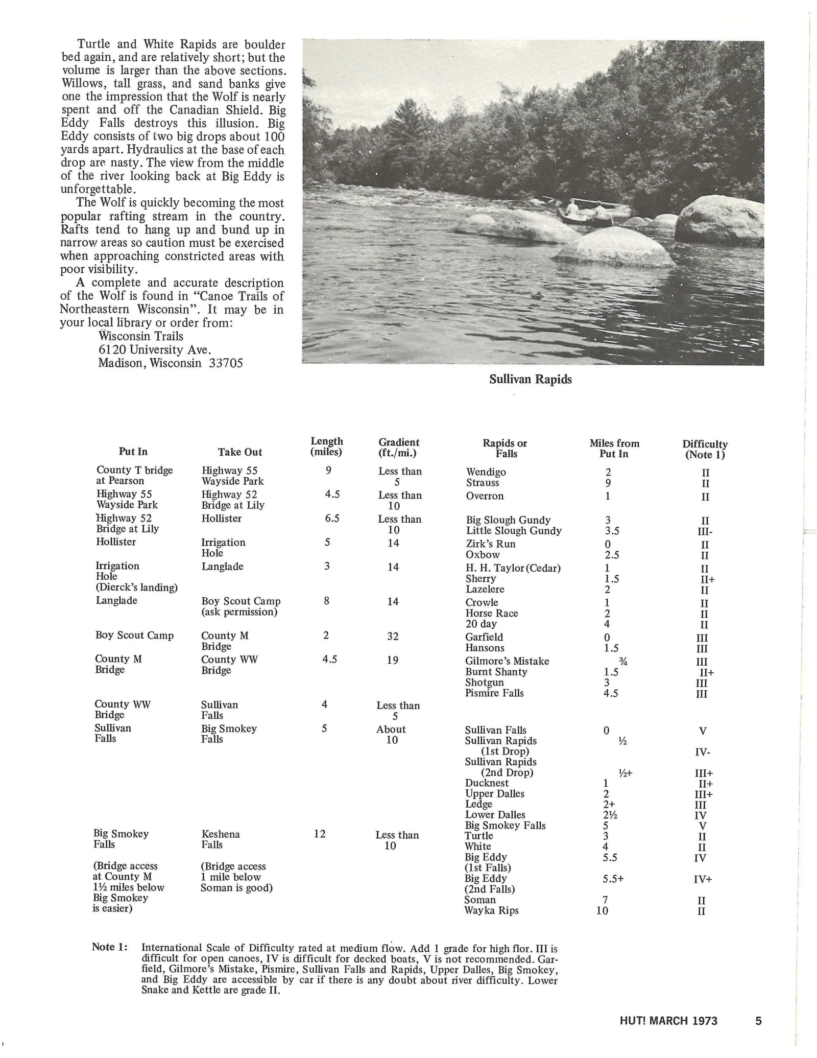
Sullivan Rapids
Length Gradient Rapids or Miles from Difficulty
Put In Take Out (miles) (ft./mi.) Falls Put In (Note 1)
County T bridge Highway 55 9 Less than Wendigo 2 II
at Pearson Wayside Park 5 Strauss 9 II
Highway 55 Highway 52 4.5 Less than Overron 1 II
Wayside Park Bridge at Lily 10
Highway 52 Hollister 6.5 Less than Big Slough Gundy 3 II
Bridge at Lily 10 Little Slough Gundy 3.5 Ill-
Hollister Irrigation 5 14 Zirk’s Run 0 II
Hole Oxbow 2.5 II
Irrigation Langlade 3 14 H. H. Taylor (Cedar) 1 II
Hole Sherry 1.5 I+
(Dierck’s landing) Lazelere 2 II
Langlade Boy Scout Camp 8 14 Crowle 1 Il
(ask permission) Horse Race 2 II
20 day 4 II
Boy Scout Camp County M 2 32 Garfield 0 Ill
Bridge Hansons 1.5 I
County M County WW 4.5 19 Gilmore’s Mistake % Ill
Bridge Bridge Burnt Shanty 1.5 II+
Shotgun 3 Ill
Pismire Falls 4.5 Ill
County WW Sullivan 4 Less than
Bridge Falls 5
Sullivan Big Smokey 5) About Sullivan Falls 0 Vv
Falls Falls 10 Sullivan Rapids ¥
(1st Drop) IV-
Sullivan Rapids
(2nd Drop) Yt IlI+
Ducknest 1 II+
Upper Dalles 2 Ti+
Ledge 2+ Ill
Lower Dalles 2% IV
. Big Smokey Falls 5 V
Big Smokey Keshena 12 Less than Turtle 3 II
Falls Falls 10 White 4 II
Big Eddy 5.5 IV
(Bridge access (Bridge access (ist Falls)
at County M 1 mile below Big Eddy 5.5+ IV+
1% miles below Soman is good) (2nd Falls)
Big Smokey Soman 7 Il
is easier) Wayka Rips 10 II
Note 1: International Scale of Difficulty rated at medium flow. Add 1 grade for high flor. III is
difficult for open canoes, IV is difficult for decked boats, V is not recommended. Gar-
field, Gilmore’s Mistake, Pismire, Sullivan Falls and Rapids, Upper Dalles, Big Smokey,
and Big Eddy are accessible by car if there is any doubt about river difficulty. Lower
Snake and Kettle are grade II.
HUT! MARCH 1973 5
Article contents & approved summaries (0)
No article summaries are available for this view.